Panoramas New Adds.

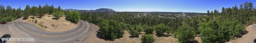
As I process new panoramas they are added here first and then will be sorted into the various categories (Route 66/Parks/etc).

I am listing them here first here so new content is easier to find. Most recent content is at the top.

Enjoy!


VR Panorama taken at the edge of Diablo Canyon at the West end of Two Guns, Arizona. The bridges are part of Interstate 40.
The rock structure at the top of the hill is a sealed water cistern.('11)
Click on the photo to view a 360 degree interactive virtual reality panorama.


VR Panorama taken East of the South end of the Route 66 bridge in Two Guns, Arizona.
This pano was taken in the same area as the previous but a little closer to the trading post ruins. ('11)
Click on the photo to view a 360 degree interactive virtual reality panorama.


VR Panorama taken East of the South end of the Route 66 bridge in Two Guns, Arizona. This pano
was taken at about the same spot as the one below, just a little closer to thege of Diablo Canyon. ('11)
Click on the photo to view a 360 degree interactive virtual reality panorama.


VR Panorama taken East of the South end of the Route 66 bridge in Two Guns, Arizona. This spot is downhill,
from the Trading Post and about halfway into an inside curve of Canyon Diablo. The original ruins (Apache Death Cave)
can be seen across the canyon along with the wagon ramp down into the canyon from the East.. ('11)
Click on the photo to view a 360 degree interactive virtual reality panorama.


VR Panorama taken West of the South end of the Route 66 bridge in Two Guns, Arizona. Well before Route 66,
the South (West) edge of Diablo Canyon was blasted to provide a way for wagons to get down into the canyon and
ford the river. For many years this was the furthest North crossing available South of the Grand Canyon. This area is
where the crossing started down into the canyon from the West. ('11)
Click on the photo to view a 360 degree interactive virtual reality panorama.


VR Panorama taken from South end of the Route 66 bridge in Two Guns, Arizona.
This is the original Route 66 roadbed through Two Guns (and is still driveable). ('11)
Click on the photo to view a 360 degree interactive virtual reality panorama.


VR Panorama taken from the top of the trading post building's cistern on the South end of the
Route 66 bridge in Two Guns, Arizona ('11)
Click on the photo to view a 360 degree interactive virtual reality panorama.


VR Panorama taken at the Route 66 Bicycle and Pedestrian Park in East Flagstaff.
This piece of '40s Route 66 pavement was still in use when 10 years ago AZ-DOT reconfigured the Country Club
Drive intersections off of I-40. Under the new configuration, this piece of Route 66 was isolated from traffic and
incorperated into the pedestrian/bike path that is between Route 66 and the RR tracks all the way through Flagstaff.
The road towards the mountain is also Route 66 as it is the original '20s alignment that follows Townsend-Winona Road ('18)
Click on the photo to view a 360 degree interactive virtual reality panorama.


VR Panorama taken from Mars Hill just outside the front gates of Lowell Observatory in Flagstaff.
The road curls up the East side of Mars Hill from the old downtown. The city of Flagstaff between NAU
and the foot of Mount Elden can be seen spread out below. ('18)
Click on the photo to view a 360 degree interactive virtual reality panorama.


VR Panorama taken on the Maidenhead Grid DM31/32 boundary line (N32 Lattitude Line).
This spot is alongside AZ85 highway North of the Lukeville border crossing and within Organ Pipe
National Monument where I was doing a 6m HAM radio activation. ('10)
Click on the photo to view a 360 degree interactive virtual reality panorama.


VR Panorama taken at Cerreta's Chocolate Factory Store in Glendale, AZ
The store was conducting their daily tour/demonstration. ('10)
Click on the photo to view a 360 degree interactive virtual reality panorama.


VR Panorama taken at the Shaffer Fishbowl Spring above Old Route 66 just below Sigreaves Pass.
If you look carefully you can actually see the goldfish in the spring. ('10)
Click on the photo to view a 360 degree interactive virtual reality panorama.


.
 Route 66
Air Guard
Classic Mustang
Font Factory
Panoramic Photography
Apple QuickTime required to view some content.