The operating plan for all trips is to run m/s FSK441 during the entire posted operating period unless Es kicks in. Then I will run m/s in the early AM, switch to Es when 6m opens, and return to m/s when Es fades. If no Es, I will continue through the entire period on m/s.
.
This year I expect that I will have cell coverage in most locations as again I will have both AT&T and Verizon internet and will be monitoring PJ. Notable exceptions include DL88 and the central Nevada desert grids. Since some of these grid locations will lack cell coverage, I will try to stick to my published plan and will depend on others to post to PJ/etc for me when I am heard. Please spot me on the various sites when you hear me if I am out of cell coverage.
For m/s FSK441; I will be CQ'ing on 50.260 and listening for calls and QSO'ing on 50.245 ONLY. Please do not call me on 50.260 as I won't hear you. As soon as I hear a ping on 50.245, I will QSY my transmit to 50.245 and operate simplex on 50.245 for as long as there are callers. Watch my CQ's as if 50.245 is QRMed or occupied I will be showing a different QSY freq. I will always be transmitting first period (standard Rover ops), and initially pointing the beam Southeast and working around counter-clockwise. If I have internet I will post QSY freq & beam azimuths on PJ and coordinate a queue.
I will be using my operating location grid as my FSK441 exchange. If I am in a single grid, I will use that (i.e. DM45). If I am on a grid boundary, I will be using both grids (i.e. 'CN9303' - meaning CN93 & DN03). If I am at a grid confluence (corner), I will be using diagonal grids (i.e. 'DM3647' meaning DM36, DM37, DM46, & DM47).
I have been asked to give the general procedure for FSK441 random operations so stations will have an idea which way I will jump. This kind of long winded but it is more art than science......
Generally, I start CQ to the Southeast and step 45 degrees at a time in the CCW direction every 3-4 cycles. I stop when I hear a reply to my CQ and 1) if I decode a call, I turn direct to the published grid of the station. If no decode, I will switch to "QRZ NJ0W" and wait for another ping. If the call's grid isn't published I will stay on the initial azimuth. 2) If no luck on direct heading, will try the HOT heading from WSJT. 3) If still no luck, will try 45 degrees left, then 45 degrees right azimuth. 4) If still no luck, will try 90 degrees left, then 90 degrees right. 5) if I still hear the station transmitting but still no exchange, I will try 180 degrees from initial azimuth. 6) If I am getting tropo I can't decode with FSK441, I will try switching ISCAT as a last resort.
Each one of the steps I will try for 3-4 cycles. If I hear you, I will keep trying to work you. If another station starts Tx, I will 1) add them to a list and try to complete our QSO, or 2) if they are too strong, I will work them to clear the frequency and return to the original QSO.
Basically, don't assume I didn't hear you because I didn't come back right away. Sometimes it can take a while.....
When working Es, I will start CQ'ing on 50.125 USB phone only and will base beam azimuth on openings. If 50.125 gets congested, I will announce QSY to a higher open frequency and operate there as long as I have callers. 50.138 will be my first choice of QSY frequency and if not available I will step up from there to the first clear frequency.
Flagstaff, AZ to Fargo, ND: 19 June - 28 June
61 driving hours over 3118 statute miles while transiting 46 grids, burning an estimated 195 gallons of regular unleaded, and programmed to log 94 operating hours in 35 different grids (147 total grid-hours)

JUNE
DATES ARE LOCAL/TIMES ARE UTC
|
19W |
1745-2145
|
.Transit DM45/55/54/53
|
.Enroute
|
|
|
2145-0045
|
.S DM53
|
.SW of Alpine, AZ
|
|
|
0045-0400
|
.Transit DM53/52/62
|
.Enroute
|
20R |
1200-1315 |
.Transit DM62/61 |
.Enroute |
|
|
1315-1515
|
.B DM51/61
|
.SW of Deming, NM
|
|
|
1515-1915
|
.Transit DM61/71
|
.Enroute
|
|
|
1915-2115
|
.B DM70/71
|
.S of Van Horn, TX
|
|
2115-2330 |
.Transit DM70 |
.Enroute |
|
|
2330-0230
|
.B DL79/DM70
|
.S of Marfa, TX
|
|
|
0230-0300
|
.Transit DM70 |
.Enroute |
21F |
1100-1115 |
.Transit DM80 |
.Enroute |
|
|
1115-1215
|
.B DM80 |
.East of Marfa, TX |
|
|
1215-1700
|
.Transit DM80/DL89/DL88 |
.Enroute |
|
|
1700-0300
|
.S DL88 |
.TY-2 Big Bend National Park, TX (see NOTE) |
|
22Sa
|
1100-1900
|
.S DL88 |
.TY-2 Big Bend National Park, TX |
|
|
1900-0300
|
.B DL88/89 |
.Pettits Road, Big Bend National Park, TX |
23Su |
1100-1900 |
.B DL88/89 |
.Pettits Road, Big Bend National Park, TX |
|
1900-0300 |
.S DL88 |
.TY-2 Big Bend National Park, TX |
|
24M
|
1100-1300
|
.S DL88 |
.TY-2 Big Bend National Park, TX |
|
|
1300-1815
|
.Transit DL88/89/DM80/DL89 |
.Enroute |
|
|
1815-2015
|
.B DL89/99 |
.SE of Sanderson, TX |
|
2015-2300 |
.Transit DL89/DM80/DM90 |
.Enroute |
|
|
2300-0100
|
.B DM90/91 |
.S of Barnhart, TX |
|
|
0100-0400
|
.Transit DM91/DM92 |
.Enroute |
25T |
1100-1200 |
.Transit DM92 |
.Enroute |
|
|
1200-1400
|
.B DM92/EM02 |
.E of Hamlin, TX |
|
|
1400-1430
|
.Transit EM02/EM03 |
.Enroute |
|
|
1430-1630
|
.B DM93/EM03 |
.SE of Old Glory, TX |
|
|
1630-1830
|
.Transit DM93/94 |
.Enroute |
|
|
1830-2130
|
.B DM94/EM04 |
.E of Paducah, TX |
|
2130-0000 |
.Transit DM95/EM05 |
.Enroute |
|
|
0000-0200
|
.B DM95/EM05 |
.W of Texola, OK |
|
|
0200-0230
|
.Transit DM95 |
.Enroute |
26W |
1100-1230 |
.Transit DMDM95/96 |
.Enroute |
|
1230-1430 |
.B DM96/EM06 |
.E of Higgins, TX |
|
1430-1600 |
.Transit EM06/07 |
.Enroute |
|
1600-1800 |
.B DM97/EM07 |
.W of Engelwood, KS |
|
1800-1945 |
.Transit EM07/DM97/EM08 |
.Enroute |
|
1945-2145 |
.B DM98/EM08 |
.W of Jetmore, KS |
|
2145-0015 |
.Transit EM08/EM18 |
.Enroute |
|
0015-0215 |
.B EM18/19 |
.N of Salina, KS |
|
0215-0230 |
.Transit EM18 |
.Enroute |
27R |
1100-1430 |
.Transit EM18/29/EN20 |
.Enroute |
|
1430-1630 |
.B EN20/30 |
.W of Ridgway, MO |
|
1630-2315 |
.Transit EN20/21/EN11/12 |
.Enroute |
|
2315-0115 |
.B EN11/12 |
.SW of Onowa, IA |
|
0115-0130 |
.Transit EN12 |
.Enroute |
|
0130-0330 |
.B EN12/22 |
.E of Onawa, IA |
|
0330-0345 |
.Transit EN12 |
.Enroute |
28F
|
1100-1430 |
.Transit EN12/23 |
.Enroute |
|
1430-1630 |
.B EN23/24 |
.W of Lake Williams, MN |
|
1630-1715 |
.Transit EN13/14 |
.Enroute |
|
1715-1915 |
.B EN13/14 |
.W of Egan , SD |
|
1915-2330 |
.Transit EN14/15/16 |
.Enroute to Fargo, ND |
NOTE: If the Weather is WET in Big Bend National Park (DL88/89) then DL88 WILL NOT be attempted.
JUNE/JULY IN FARGO, ND (EN16)
DATES ARE LOCAL/TIMES ARE UTC
|
TBD
|
TBD
|
.B EN16/17
|
.Just North of Fargo
|
Note:
While in Fargo, I can activate EN16 and possibly EN17. EMail for a sched.
Fargo, ND to Flagstaff, AZ: 20 July - 28 July
48.4 driving hours over 2582 statute miles while transiting 36 grids, burning an estimated 161 gallons of regular unleaded,
and programmed to log 61.5 operating hours in 24 different grids (195 total grid-hours)

The three Confluences (grid corners) in Nevada are only accessible if it is dry (as in no rain/snow/etc). In 2011 it was raining so I used alternate grid boundaries to get the same grids. This year I will again have to evaluate conditions when I get there. The chances that DM18/19/28/29 will have cell coverage is virtually zero so watch my grid exchange. I would expect all the other locations to have either AT&T or Verizon available but I have been wrong before.
Planned times will be maintained as much as possible but weather, road conditions, and inaccessible locations can cause detours and delays. I have researched the planned locations and they should all be accessible, but in previou years I encountered numerous instances of new 'No Trespassing' postings that kept me from getting where I wanted too. In other words, I will try but I cannot guarantee success.
JULY
DATES ARE LOCAL/TIMES ARE UTC
20Sa
|
1700-0300
|
.Transit EN16/06/07
|
.Enroute
|
21Su
|
1100-1930 |
.Transit EN07/06/DN96/95 |
.Enroute |
|
|
1930-0000
|
.B DN92/93
|
.N of Merriman, NE (in SD)
|
|
|
0000-0200
|
.Transit DN92/82
|
.Enroute
|
|
|
0200-0400
|
.B DN82/83
|
.NW of Chadron, NE (in SD)
|
22M |
1200-1400 |
.B DN82/83 |
.NW of Chadron, NE (in SD) |
|
|
1400-2115
|
.Transit DN82/81/71/70/60
|
.Enroute
|
|
|
2115-2215
|
.S DN60
|
.W of Kremmling, CO
|
|
|
2215-0230
|
.Transit DM69/59
|
.Enroute
|
|
|
0230-0400
|
.B DM58/59
|
.N of Cisco, UT
|
23T |
1200-1400 |
.B DM58/59 |
.N of Cisco, UT |
|
|
1400-1500
|
.Transit DM58/48
|
.Enroute
|
|
|
1500-1700
|
.B DM48/49
|
.W of Green River, UT
|
|
|
1700-1900
|
.Transit DM48/39
|
.Enroute
|
|
|
1900-0400
|
.C DM28/29/38/39***
|
.E of Baker, NV
|
24W |
1200-1500 |
.C DM28/29/38/39*** |
.E of Baker, NV |
|
|
1500-1845
|
.Transit DM29/DN20
|
.Enroute
|
|
1845-2030 |
.S DN20 |
.SW of Wendover, UT (in NV) |
|
|
2030-2215
|
.Transit DN20/21
|
.Enroute
|
|
|
2215-0015
|
.B DN20/21*** |
.E of Elko, NVacob Lake & Marble Canyon, AZ
|
|
|
0015-0100
|
.Transit DN20
|
.Enroute
|
|
|
0100-0400
|
.B DN10/20***
|
.E of Carlin, NV
|
25R |
1200-1500 |
.B DN10/20*** |
.E of Carlin, NV |
|
|
1500-1915
|
.Transit DN10/DM19/29
|
.Enroute
|
|
1915-0400 |
.C DM18/19/28/29**** |
.Out in the middle of &#$@ nowhere in Nevada |
26F |
1200-1600 |
.C DM18/19/28/29**** |
.Out in the middle of &#$@ nowhere in Nevada |
|
1600-1830 |
.Transit DM28/18/17 |
.Enroute |
|
1830-0400 |
.C DM17/18/27/28**** |
.SE of Warm Springs, NV |
27Sa |
1200-1500 |
.C DM17/18/27/28**** |
.SE of Warm Springs, NV |
|
1500-1800 |
.Transit DM17/27/26 |
.Enroute |
28Su |
1800-2000 |
.Transit DM26/25 |
.Enroute |
|
2000-2200 |
.B DM24/25 |
.SW of Kingman, AZ (arrival time may vary from planned) |
|
2200-0030 |
.Transit DM25/35/45 |
.Enroute to Flagstaff, AZ |
Notes:
Dates are Local
Times are UTC/Zulu
S - Single Grid Operation
B - Grid Boundary Operation (2-fer-1). Will announce Both Grids.**
C - Grid Confluence Operation (4-fer-1). Will announce Diagonal Grids.**
** - Planned Grid Boundaries and Confluence locations should not be a problem (thank you Degree Confluence Project). However, if upon arrival access has changed, alternate boundary locations have already been determined. In the case of Confluences, two boundary locations will be used and the block time will be split between them (priority will be given to FFMA designated Rare-Grids).
*** - It appears there may be issues with rainfall in the Utah/Nevada border area. If off-road conditions are found to be too wet, these grid locations may be altered from planned: The DM28/29/38/39 confluence will be split into two boundary operations, DN20/21 may change to just DN21, DN10/20 will split into DN20 & DN10. If PJ is not available, watch my grid exchange carefully.
**** - It appears there may be issues with rainfall in the central Nevada Desert. If desert conditions are wet upon arrival, I will split these these two confluences into 3 Boundary operations (DM19/29, DM18/28, and DM17/27). If PJ is not available, watch my grid exchange carefully.
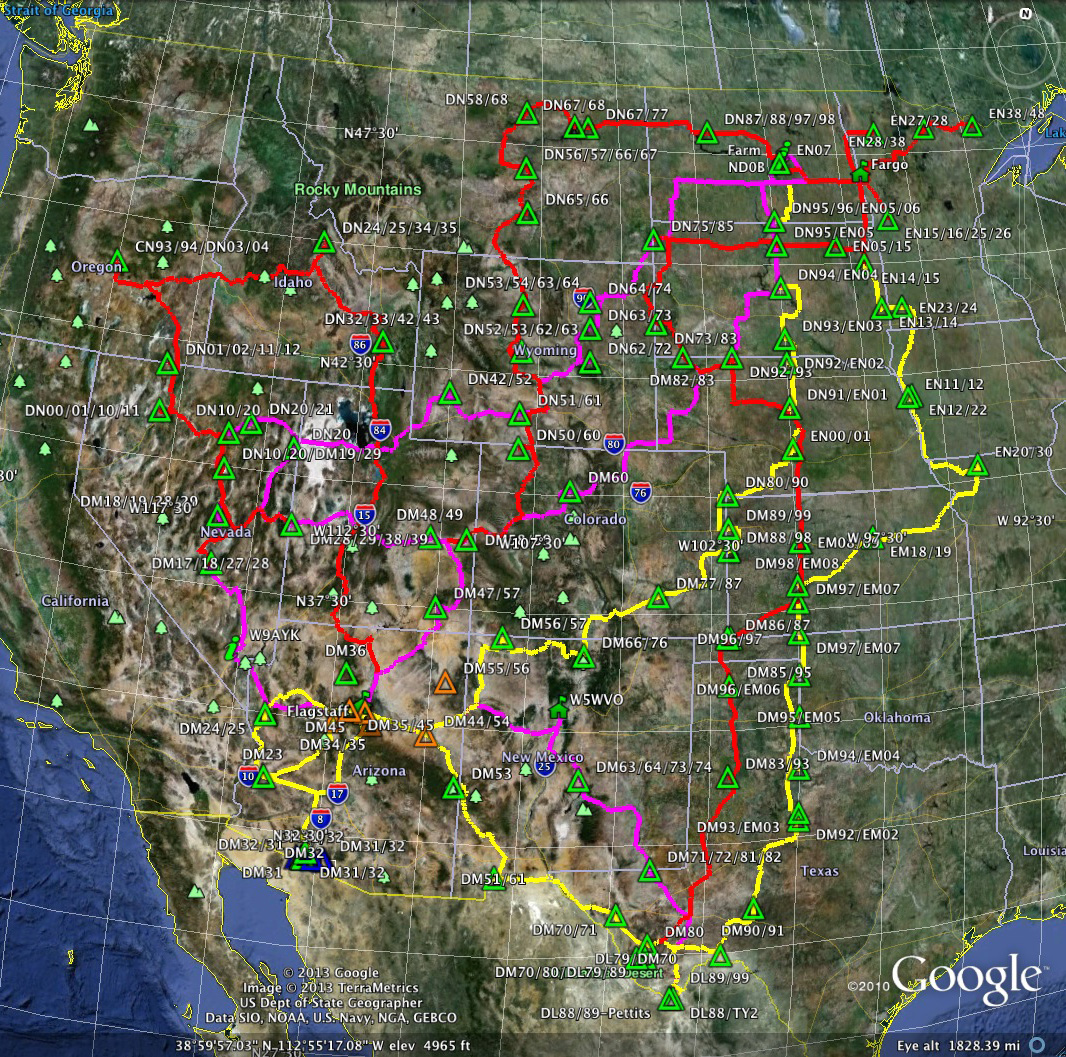
I've had some people wondering about my route choices. The following graphic provides a 'bigger' picture of how all my trips fit together. Generally, I try to avoid places I have been before but I do make exceptions if there are a number of requests or if there are special circumstances.